Wednesday, March 30, 2011

Day 18

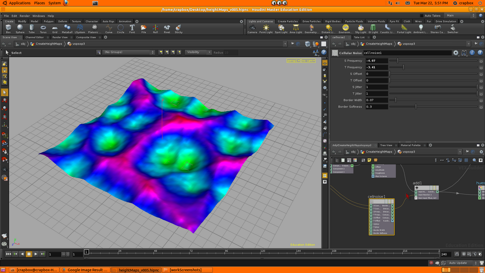
Right now there're a few important things which have come up to my mind about the terrain. A low resolution version of the terrain could be used to simulate the cracking (lesser subdivisions). Afterwards when we render we could bump up the subdivisions and increase the height map resolution. How to do that? We'll figure out soon enough.

I've received detailed replies from pclaes and an administrator from odforce on my thread.

Once again the thread I posted is about how I can go about modelling the extruded rocks and arc-shaped structures on the terrain. What methods I should begin with.

These are several advices from pclaes:

[For the level of detail that you have in the matte painting I would recommend working on individual separate chunks rather than trying to do it all in one surface. Kinda like putting different pieces of a puzzle together.
It will make your life a lot easier when it comes to texturing and repositioning to adjust the landscape for your desired composition.

I would start with basic polygonal shapes (not really metaballs as their geometry is pretty useless when you want to subdivide them). Make basic shapes (spikes, the semi-arc, perhaps a more plateau like fracture plate). Then use vop sop with various noise patterns (remapped noise, exponential noise, different levels of frequency and magnitude) to layer the detail by displacing your geometry. You could mix in bits of texture too. Perhaps research a bit on erosion patterns.

In regards to the rocks, it's the same approach, just use basic boxes or low resolution spheres as starting objects. I would also consider scattering them over the terrain and rendering them as delayed load instances (have a look on my blog if you don't know how to do that), because you might need a lot to make it look good.

Some shapes do create a specific silhouette, so you might want to model them a bit more detailed. If it is your goal as an exercise to be more procedural than using metaballs and volumes will probably give you interesting results too. But you will still need basic shapes/pointclouds to define the area where you want to copy the metaballs or where you want to read in the volume.

The geometry with the heightmap can be used to sit behind some of those chunks... almost as if it is the sand/dirt in which the massive rock pikes are sticking out from.
You blend the two through adding bits of rock, vegetation (even if it's dead), other props you have sticking in the ground, shading (occlusion pass, potentially remapped to reveal different material -> wear), and add a fog volume to get that hazy feel.

In regards to being creative with rocks. Do a search for Macha's rock thread.]
-----------------------------------------------------------------------------------------------

I also know that this might be slightly too late but the admin michael in odforce recommended using terragen 2 to generate a terrain. According to Jiabao the height map we have should be good enough thus the method of transiting from a low-poly to high-poly height map terrain in Houdini should prove useful.

There is also one more slight problem which I've just noticed. The valley I created in the height map for the flood to simulate through seems a little narrow.  Thus I expended the grid size a little. I'm thinking about whether it's necessary to edit the height map in photoshop.


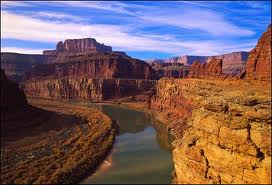
Lastly I've checked out some generated terrains done in terragen 2. This is what I found which could possibly be similar to the valley which I'm modelling.

Day 17

Today we had an interview appointment with the directors at NUS. The interview went pretty well. I told them of my ambition and the reasons why I want to go to LA for the SideFX attachment. One of the reasons is that the project I'm working on in LA would be used as part of a CG animated series side project which I'm working on currently.

Speaking of which, I've changed the storyline of the project which we have to work on in LA. I've made it much less complicated than my previous idea which involved the destruction of a city under siege by an army, followed by a nuclear explosion in the middle of a city.

My new idea involves two apaches retreating from a battlezone due to an imminent nuclear strike on their position. Both of the apaches get hit by the radius of the blast and one of the apache crash lands onto the camera causing a sudden black transition to end off the shot. My main reference would come from a scene in Call of Duty 4 Modern Warfare where some unlucky helicopters crash land due to a nuclear explosion in the desert.

Monday, March 28, 2011

Day 16

Today I've researched on other methods to model.

I've also done a few touch ups on the height map.

I've created a new thread on odforce, hopefully I might recieve more new ideas on how to create a digital asset which can generate random shapes of rock structures.

Mr Ron helped me start off with a file using metaballs.

Friday, March 25, 2011

Day 15

Detailed height map painting still in progress, here are some screen shots. I'm aiming for a Y shaped valley design. Once I'm done with the height map I'll proceed to adding in the procedural terrain additions (mostly rocks and arcs). It will most likely turn into a digital asset.


Day 14

Today after Mr Douglas reviewed our progress, he provided a useful reference image for me to refer to while designing the terrain using height maps. I will add procedurally modelled rocks and arcs in the terrain.

Painting of detailed height map is still in progress.

Some useful reference images:


Wednesday, March 23, 2011

Day 13

I spent the day painting versions of low resolution and mid resolution height maps in photoshop.

From time to time I previewed the terrain layout by importing the height maps into the houdini height map file which I set up yesterday.

Problems faced:

Something wrong with the network connectivity which makes it tedious to manually transfer work data from windows to the ubuntu desktop.

High resolution height maps are very heavy in data causing the houdini scene file to lag a lot, thus showing that cracking and shattering geometry in it might cause houdini to crash.


Tuesday, March 22, 2011

Day 12

I've started setting up a hipc file to import a height map in.

There're two ways to generate a terrain currently, one is to use cellnoise and anti alias noise, another is to use height maps.

I followed Khermah's tutorials for this topic.

I used Jiabao's height map template and edited it in photoshop.


Monday, March 21, 2011

Day 11

I've volunteered to model the terrain for the dragon flood sequence.
Here's some initial modelling I've spent time on using mountain and sculpt tool.

I will use height maps for the terrain by referring to a houdini height maps tutorial created by a Youtube user Khermah.


Sunday, March 20, 2011

Day 10

In the morning I helped the other DVE FYP group by acting as the director in their shot.

Research of smoke and debris using pyro fx and fluids continues.


Friday, March 18, 2011

Day 9

Smoke and dust emits from cracks and debris crashing. Today after Mr Douglas left I did some research and downloaded some smoke files to explore.


Wednesday, March 16, 2011

Day 8

Today Mr Leong approached me to assist with the testing of the new motion-capture equipment our school supplier has provided. I've learnt a few new things about the setting up of a motion-capture studio like calibration of the cameras using a special T shaped tool.

I'm still experimenting on using invisible secondary geometries to collide into the ground and shatter it.


Day 7

I've downloaded a number of cracking/ debris files to play around with.

I've also managed to find Minguel Perez's .hip files but I had problems opening them with Houdini 11.

Tuesday, March 15, 2011


Day 6

After watching Minguel Perez's demo reel, I came across a scene where he did a ground shatter of the road.

I'm also trying to find different and ways to shatter the ground, such as forcing a geometry through the surface of the ground.